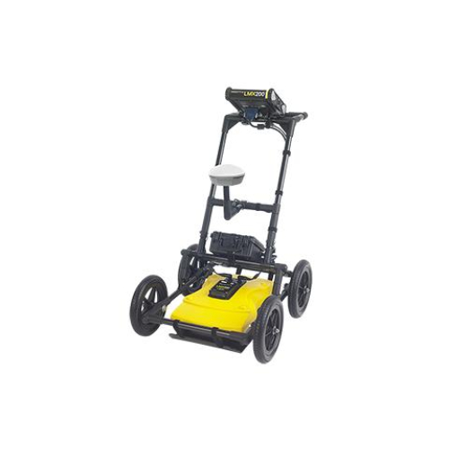
LMX100 is the Premier Ground Penetrating Radar (GPR) for Utility Locating Equipment in the market. It provides the perfect frequency, data processing power and filters for detecting utilities and traditionally non-locatable features such as:
- Non-metallic pipes, including PVC and asbestos cement
- Underground Electrical Cable
- Concrete storm and sewer systems
- Utilities where installed tracer wiring has failed
- Underground storage tanks and drainage tiles
- Septic system components
- Non-utility structures such as vaults, foundation walls and concrete pads
Rapidly Locate & Mark metallic and non-metallic utilities
As one of the most affordable GPR utility locating tools in the market today, the LMX100™ completes the locator’s toolbox, offering a more complete picture of the underground infrastructure. With a simple, easy-to-use interface it also offers the perfect balance of depth penetration and high resolution for accurate locating.
The LMX family is a non-destructive Ground Penetrating Radar (GPR) that can locate utilities that cannot be located using traditional methods (e.g. plastic pipes or utilities that contain broken tracer wires).LMX® has the advantage of detecting:Metallic and non-metallic utilitiesUtilities with broken tracer wires.
Undocumented utilities
Trenches and disturbed soil often associated with utility burialUnexpected obstacles or buried structures such as old foundations that can cause problems for excavations or construction
The LMX100 is designed to find all buried pipes and cables. Features include internal GPS, on-board Wi-Fi, a high resolution touch screen as well as the proprietary FrequenSee™ technology which selectively enhances small/shallow, medium size/depth, or large/deep targets, or even all at once, for easier viewing and detection.
Mini reports can be generated and delivered directly from the survey site by connecting to a Wi-Fi network or by using a cell phone as a hotspot. Data can also be exported to a USB memory stick.
FrequenSee™ “3 Antennas in One”
FrequenSee™ selectively enhances small/shallow, medium size/depth, or large/deep targets, or even all, for easier viewing and detection. The proprietary FrequenSee™ technology exploits the wide bandwidth of the LMX antenna, and allows the user to select the low, medium or high part of the frequency spectrum to focus on the desired features. Systems incorporating FrequenSee are typically lighter and less bulky that competing multi-antenna alternatives.
GPS
The LMX100 includes internal GPS as standard. Files can be opened in Google™ Earth™, giving all the geographic position of where saved surveys were performed and the ability to view the screenshots that were taken.
Internal Wi-Fi and USB for data transfer
Mini projects, containing screenshots and a table with information about the collected data, can be emailed immediately to clients or colleagues using the on-board Wi-Fi, either via a nearby wireless network or the user’s smart phone in hotspot mode. Screenshot images, and data for Enhancement system users, can also be exported to a USB drive for transfer to a computer or archive system.
High resolution touch screen display
The high resolution Display Unit features touch screen operation, providing the user with the ability to draw arrows on the screen to highlight features of interest. Soil calibrations are simply done by dragging a Soil Cal Hyperbola to lie over a real hyperbola from the ground and matching the shape.
LMX100 KIT INCLUDES:
- 8.0"diagonal, high-visibility, sunlight-readable LCD color display with touchscreen
- internal GPS for geotagging screen captures
- built-in Wi-Fi, allowing you to send mini-reports from the field
- Sensor assembly
- data markers to highlight features on your data
- GPR sled with medium wheels
- USB for quick data transfer
- Rechargeable Lead acid battery with AC charger
- 1 year warranty
Our Sensors & Software LMX100 completes the locator’s toolbox, offering a more complete picture of the underground infrastructure. With a simple, easy-to-use interface it also offers the perfect balance of depth penetration and high resolution for accurate locating.


